Amazing LIDAR Image Reveals Scruton’s Ancient Past
Whilst working long hours I often think about those who worked upon the land before me and their lives. Listening to Radio 4 helps pass the time and I recently came across a programme about the use of LIDAR in archaeology (think LI ght ra DAR ). A search on Google revealed images of Scruton showing the ground level with all of the buildings removed. It was like looking from above at the village 700 years ago. The rigs and furrows of the fields showed up, also some moats as well as ancient paths.

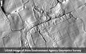
What surprised me was that I could also see ancient ditches following expected courses and fish ponds which were kept by the Lord of the Manor. Almost every acre in the Parish was ploughed before the Black Death wiped out so much of the population. With a shortage of villains it became customary for the Lords to create parkland for their use. It seems strange, in a time of global pandemic, to be able to look back into the shadows of the village which was here before the first global pandemic.